Loading... Please wait...

- Home
- Maps by State
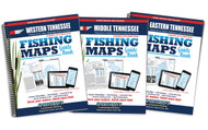
- Tennessee
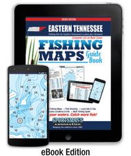
- Eastern Tennessee Fishing Map Guide - Print Edition

roll over the image to zoom or click to enlarge
)
Eastern Tennessee Fishing Map Guide - Print Edition

Save more when you order 2 or more items
| This product is available for pre-order only |
Product Description
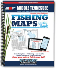
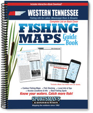
The Eastern Tennessee Fishing Map Guide is a thorough, easy-to-use collection of detailed contour lake maps, fish stocking data, and the best fishing spots and tips from area experts.
The book features fishing maps, detailed area road maps and exhaustive fishing information for Eastern Tennessee’s truly unique fishing waters, including several TVA reservoirs nestled in the mountains and some of the state's best trout streams. It’s all wrapped up in this handy, 240-page, 8 ½ x 11” spiral-bound volume.
Features editorial by Jeff Samsel, Larry Self and Vernon Summerlin.
Whether you’re after stripers on Cherokee Lake, smallies on Watauga Lake or trout on the South Holston River, you'll find all the information you need to help you enjoy a successful day out on the water on one of Tennessee’s many excellent fisheries.
Know your waters. Catch more fish with the Eastern Tennessee Fishing Map Guide.
Get a free, immediate download of the eBook Edition with purchase - everything you love about the print edition on your phone, tablet, or computer. Whether you prefer to research, take notes and print maps from home or go straight to the lake, this digital version allows you to access your maps and information from any of your devices anytime you need them. Each purchase will also give you instant access to a free future download of the Interactive Edition featuring expanded access information, current fishing reports, and more! The file is downloadable, which means you don't have to worry about trying to find an internet connection to access your maps when you are enjoying your time on the lake.
For gift orders, please indicate in the Order Comments/Instructions section at checkout that your order is a gift and a gift receipt with eBook download instructions for the recipient will be included.
| Lake Name | Acres | County |
| Boone Reservoir aka Boone Lake | 4,520 | Sullivan, Washington |
| Calderwood Reservoir | 536 | Blount, Monroe |
| Campbell Cove Lake | 77 | Polk |
| Cherokee, Lake | 30,300 | Grainger, Hamblen, Hawkin |
| Chilhowee Lake | 1,747 | Blount |
| Cove Lake | 210 | Campbell |
| Davy Crockett aka Nolichucky Reservoir | Greene | |
| Douglas Lake aka Douglas Reservoir | 30,600 | Cocke, Hamblin, Jefferson |
| Fort Loudoun Lake | 14,600 | Blount, Knox, Loudon |
| Fort Patrick Henry Lake | 893 | Sullivan |
| Holston Lake, South | 6,336 | Sullivan |
| Indian Boundary Lake | 96 | Monroe |
| Indian Mountain State Park Lakes | 21 | Campbell |
| Melton Hill Lake | 5,720 | Anderson, Kent, Knox, Lou |
| Norris Lake | 34,200 | Anderson, Campbell, Claib |
| Parksville aka Lake Ocoee | 1,930 | Bradley, Polk |
| Tellico Reservoir aka Tellico Lake | 16,056 | Blount, Loudon, Monroe |
| Watauga Lake | 6,430 | Carter, Johnson |
| Wilbur Lake | 72 | Carter |
| Watershed |
| Clear Fork of the Cumberland Watershed |
| Clinch River (Upper) Watershed |
| Clinch River Watershed |
| Conasauga River Watershed |
| Fort Loudoun Lake Watershed |
| French Broad River (Lower) Watershed |
| French Broad River Watershed |
| Hiwassee River Watershed |
| Holston River (North Fork) Watershed |
| Holston River (South Fork) Watershed |
| Holston River Watershed |
| Little Tennessee River Watershed |
| Nolichucky River Watershed |
| Ocoee River Watershed |
| Pigeon River Watershed |
| Powell River Watershed |
| Watauga River Watershed |