 Loading... Please wait...


- Home
- All-Outdoors Atlases
- Minnesota
Overview
These 15x11", spiral-bound Minnesota All-Outdoors Atlas & Field Guides are created at twice the scale of other road atlases, which means four times the detail. In addition to our unparalleled maps, you'll find comprehensive info on a range of activities that includes fishing, hunting, camping, hiking, biking, off-roading, paddling, skiing, golfing, wildlife viewing, and more through helpful editorials and extensive tables. Best of all, the data is cross-referenced and indexed to the map pages in a way that's fun and easy to use. Whether you're planning an afternoon bike ride or an extended camping trip, these atlases will help you enjoy the extraordinarily diverse and numerous outdoor area across Minnesota. Inside you'll find:
- Fishing Lakes, Rivers, Streams, Canoe and Kayak routes
- Public Hunting, State & National Forest Areas, Gathering and Foraging
- Golf Courses, Campgrounds, State Park Locations
- Hiking, Biking, Skiing, ATV, Snowmobiling, & Equestrian Trails
- Wildlife-Viewing, Scenic Drives, Sightseeing Info


Twice the scale, double the detail
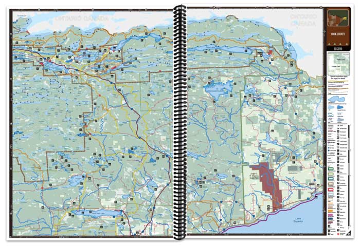
Each map page presents a highly detailed view of individual sections of Minnesota in rich, full color. A full legend, coordinates, and easy-to-read symbols tied to informative tables make it a snap to find the locations and facilities to enjoy your favorite outdoor activities.
- 1:100,000 scale
- Full legend on every map page
- Latitude and longitude coordinates
- Public/private land boundaries, forests, designated use areas, unimproved roads, trails, marshes, campgrounds, fishing opportunities, golf courses, points of interest, and much more.


Camping
Comprehensive information on ALL of Minnesota's campgrounds, public and private, from primitive to RV sites, complete with comprehensive tables for each, cross referenced back to the detailed map pages. Other tables and detailed maps for all public campgrounds with information on amenities are also included for state parks, county parks, state forests, national forests, Voyageur's National Park, BWCA, boondoc, remote sites and more! If you're a camper, you won't find a more accurate and comprehensive source for ALL of your camping options.

Canoeing & Kayaking
Designated and other Minnesota canoeing and kayaking rivers are highlighted in your All-Outdoors Atlas & Field Guides with maps that feature access, rapids dams, portages, shelters, campsites and other information!

Fishing Lakes, Rivers, & Streams
All-Outdoors Atlas & Field Guides include extensive how-to, when-to and where-to information covering Minnesota's great fishing opportunities, whether you’re after game fish - walleye, northern pike, musky, largemouth bass, smallmouth bass, catfish, or panfish - crappie, bluegill, perch, or white bass. Fishing information is also included to help you locate and catch lake trout, brown trout, brook trout, rainbow trout, splake, chinook salmon, coho salmon with extensive tables on virtually every publicly assessable lake in the state as featured in the Sportsman's Connection Fishing Map Guides - your perfect companion to the All-Outdoors Atlas. Each table is cross-referenced back to the map pages that are TWICE the scale of other state atlases!

Your All-Outdoors Atlas & Field Guides include Minnesota river and stream fishing information with maps and tables on trout fishing opportunities throughout the state. All trout streams are highlighted on each map page.

Golfing
Through tables and overview maps cross referenced to map pages at twice the scale of other state atlases, identification and location of Minnesota's golf courses is made easy through your All-Outdoors Atlas & Field Guides.

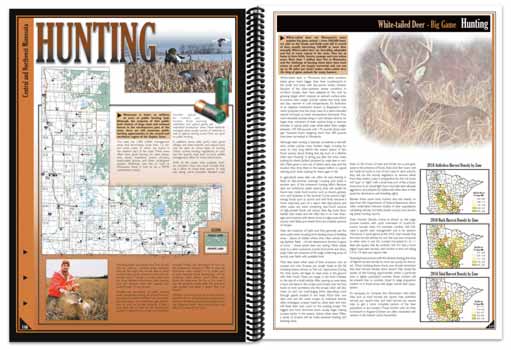
Hunting
Your All-Outdoors Atlas & Field Guides include extensive how-to, when-to and where-to information covering Minnesota's great hunting opportunities, whether you're after big game such as deer, bear or moose, upland game such as grouse, pheasant or woodcock, waterfowl - ducks and geese - or other small game. Informational tables are included for wildlife management areas with species presence, cover type, size, location and tips cross-referenced back to detailed maps at twice the scale of other atlases. All this plus other public land information make this a hunting atlas like no other!
State & National Forests
All Minnesota state and national forests are featured in your All-Outdoors Atlas & Field Guides, including information on trails, campgrounds and recreational sites.

Skiing
Minnesota's extensive cross-country ski trails and downhill ski sites are identified in detail in your All-Outdoors Atlas & Field Guides through tables and overview maps that cross-reference back to the map pages that are twice the scale and double the detail of other atlases.

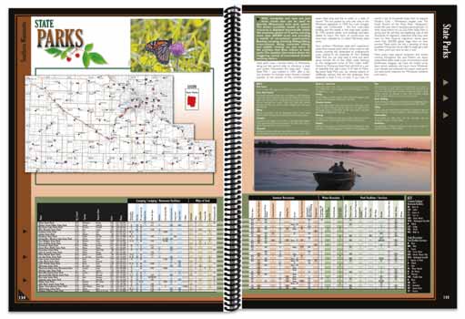
State & County Parks and Recreation Areas
Minnesota's State and County Parks are covered in detail in your All-Outdoors Atlas & Field Guides through maps and tables detailing each park and its amenities, including opportunities for camping, fishing, hiking, cross-country skiing, snowshoeing, picnicking and more!
Hiking, Biking, ATVing, Snowmobiling, & more
One of the best ways to take in the great outdoors is hiking and biking the extensive trail systems that Minnesota has to offer. Your All-Outdoors Atlas & Field Guides detail virtually every trail in the area - from popular state trails to local and regional hiking and biking trail systems. The hiking and biking trails section calls out suggested trails cross-referenced back to the detailed map pages at twice the scale of other state atlases. Other sections of the All-Outdoors Atlas & Field Guides include additional trail information within our many parks and forests, virtually all of which are available for hiking and biking.

Minnesota boasts some of the most extensive and developed networks of snowmobile and ATV trails in the nation. Each All-Outdoors Atlas & Field Guide features these trails in tables and maps that are the most detailed and complete that you can find anywhere! At over twice the scale of other state atlases, the detail is unmatched!

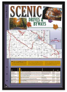
Scenic Drives
With diverse topography and a rich cultural heritage, there is no better way to see the scenic beauty of Minnesota than to get off the main highway and travel some small backcountry roads. Your All-Outdoors Atlas will help you get there through extensive tables cross-referenced with detailed maps.
Wildlife Viewing
Minnesota abounds with wildlife! Whether you'e a serious bird watcher or just enjoy viewing wildlife whenever you have the opportunity to get outdoors, your All-Outdoors Atlas & Field Guides provide information and pictures on our area's mammals and birds including some of the better viewing areas, cross-referenced to the detailed map pages at twice the scale of other state atlases!

Voyageurs National Park
Voyageur's National Park is featured in the Northeastern Minnesota All-Outdoors Atlas & Field Guide with overview maps and detailed tables with comprehensive information on camping, accommodations and services, cross referenced to detailed map pages that are twice the scale of other state atlases.

Boundary Waters
At over 1 million acres, the Boundary Waters Canoe Area Wilderness is a massive playground for the canoeist, angler, nature lover and wilderness adventurer. The Northeastern Minnesota All-Outdoors Atlas & Field Guide features exhaustive coverage of this Canadian Shield wonderland with information on entry points, campsites, outfitters, fishing lakes and more through comprehensive tables and overview maps, each cross-referenced back to the most detailed map pages on the market - twice the scale of other state atlases!

Order the print edition today and receive a free, immediate download of the eBook Edition (a $17.95 value)!
Click the cover images to learn more about each book